It’s a Good Time for a Creek Connection
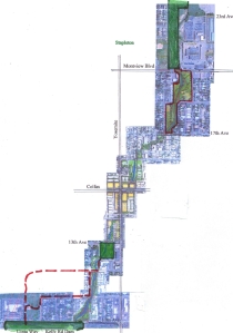
In June of 2011, Denver City Council approved the Westerly Creek Greenway Master Plan, which provided recommendations for a greenway corridor along Westerly Creek from Lowry to Stapleton. Staff and elected officials from Denver and from the City of Aurora served on the Steering Committee for the Master Plan; roughly half of the study corridor is in each city. Aurora did not formally adopt the Master Plan, but the document was one of a number of references for master planning prepared by the city for that area of Aurora.
In the summer of 2012, New Freedom Park, at 13th Avenue and Xenia Street in Denver, was dedicated, with a large number of local residents present at the ceremony. Many of those residents are refugees from Africa and Asia, trading their lives in war-torn countries like Bhutan and Rwanda for new lives in Colorado. They came up with the name “New Freedom Park” for the new park. It was both appropriate and touching to see then-Mayor Guillermo Vidal, himself a former refugee from Cuba, at the park dedication.
A New Greenway Project Is Coming to Aurora
The greenway at Stapleton currently ends at Montview Boulevard. Immediately south of Montview Boulevard is Aurora’s Montclair Park, with Westerly Creek essentially splitting the park in two parts, one to the east of the creek, and one to the west. Aurora has received a grant from FEMA to reduce the flood risk facing a large number of homes surrounding the park. The grant will pay to replace the existing culvert crossing of Montview Boulevard with a bridge. Installing the bridge will allow bicyclists and pedestrians to pass under Montview, through Montclair Park, all the way to 17th Avenue. While it may take a number of years to implement, Aurora has a plan for flood hazard reduction improvements from 17th Avenue to the intersection of Colfax and Yosemite, including some stream daylighting between 17th and 16th.
Possibilities for a New Greenway Project in Denver
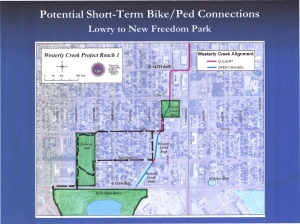
The Westerly Creek greenway at Lowry ends at 11th Avenue. Immediately north of 11th Avenue, under the shadow of Kelly Road Dam (a flood control facility that partially reduces flood flows on Westerly Creek), is Verbena Park. The 2011 Greenway Master Plan provided guidance for extending the greenway from Lowry, starting at 11th and Willow, two blocks to the east of Verbena Park, following the creek, whether it is currently in an open channel or buried in storm sewer pipes. Following the channel near Willow Street is the long-term plan for extending the greenway, but in the short-term, it would be possible for Denver to design and install a safe crossing of 11th from Lowry into Verbena Park. From there, both Richthofen Place (a designated Green Street) and 12th Avenue (a designated bicycle route) continue east to Westerly Creek. At 12th Avenue, between Xanthia and Xenia, the creek enters a storm sewer, under the alley. Halfway from 12th to 13th Avenue, the storm sewer ends, with an outlet into the open channel of Westerly Creek in New Freedom Park. The Master Plan provides recommendations for the Denver portion of the corridor to continue to Colfax and Yosemite, to meet the Aurora portion.

Potential Short –Term Improvements in Denver
2013 would be a good year for Denver to develop an interim bike/ped corridor from Lowry to New Freedom Park, in anticipation of a long-term greenway corridor. Denver would be extending the greenway in the direction of Aurora at the same time that Aurora was extending the greenway in the direction of Denver. The short-term improvements between Lowry and New Freedom Park would include:
- A safe crosswalk across 11th Avenue from Lowry (where the trail on the face of Kelly Road Dam intersects 11th) into the southwest corner of Verbena Park.
- Signage in Verbena Park.
- Paint and signage along Richthofen Place from Verbena to Xanthia, along Xanthia from Richthofen to 12th (for pedestrians), and along 12th Avenue from Verbena to the alley just east of Xanthia (for bicycles).
- Paint, signage and some form of traffic/parking control for the alley from 12th Avenue to the southwest corner of New Freedom Park.

Creek Restoration Walks Scheduled for February In order to show interested pedestrians and cyclists the possibilities for linking Lowry and Stapleton, I am leading 4 walks in February, one each Saturday morning, at 10:00 a.m.
- Two walks, February 2 and 16, will start and end at Lowry, from the parking area south of Big Bear Ice Arena, next to the entrance to the Lowry Dog Park.
- Two walks, February 9 and 23, will start and end at Stapleton, at the Smith Road trailhead for the Sand Creek Greenway, just north of the pedestrian bridge over Sand Creek.
The walks are each approximately 4.5 miles in total length, each turning around at Colfax and Yosemite, and they will happen, snow or shine, warm or cold. Come on out and help to transform our community. If you like the potential that you see in the corridor, do what it takes to make it happen. Each of you holds a key to growing our greenway.
An expert in floodplain management, Brian Hyde can be reached at westerly_connect_brian@comcast.net or 720-939-6039.
