Redrawn Map Makes Park Hill Whole
By Councilman Christopher Herndon
At least once every 10 years, the Denver City Council must redraw its district boundaries based on the latest U.S. Census data. According to the Denver Charter, the city is to be evenly divided into 11 council districts to honor the principle of “one person-one vote.” Other rules dictate that each district must: be as compact as possible; contain contiguous land area; contain whole election precincts; and have boundaries established by ordinance.
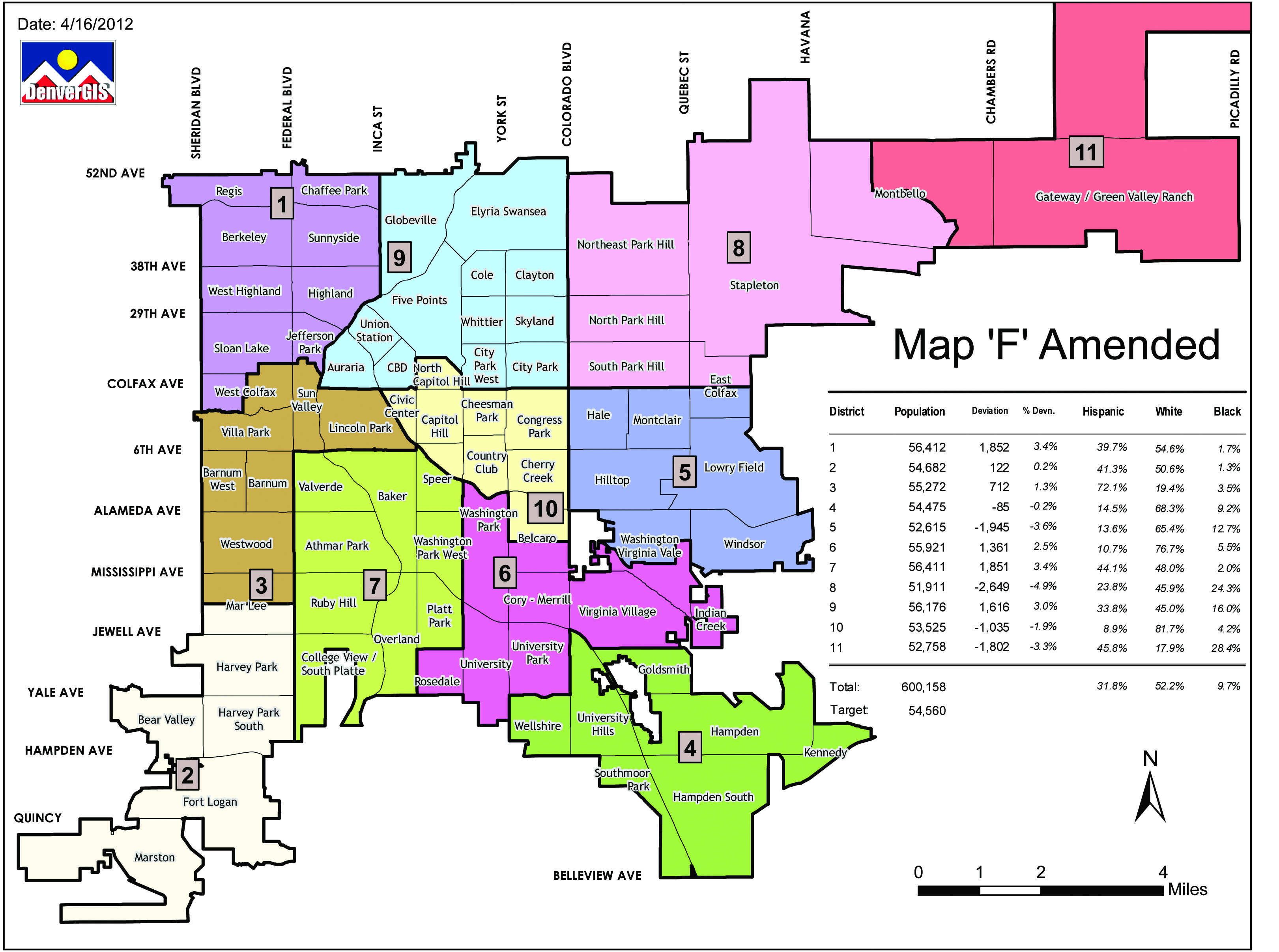
The Denver City Council established new council district boundaries on April 30, 2011. The new map will be effective for purposes of the 2015 municipal election.
In May 2015, residents of Green Valley Ranch, Parkfield, and most of Montbello will elect a new representative to the new Denver City Council District 11. I will continue to represent Northeast Park Hill to Denver International Airport until mid-July 2015 when the new council members are sworn in. I will run for re-election in the new District 8, which includes a small portion of Montbello, all of Stapleton, and all of Park Hill.
Between the 2000 census and the 2010 census, Denver’s population grew by more than 45,000 people, roughly 35,000 of whom relocated to Council District 11.
When we began the redistricting process, the City Attorney briefed council members on the specific requirements to which we needed to adhere, including ensuring that each district contain approximately 55,000 people with a 5% margin of error. Part of our guidance was to try to use naturally defined borders such as obvious thoroughfares, highways, and rivers.
In looking at the population change in Far Northeast Denver, it was immediately evident that the landscape of our district was going to change dramatically. Lines were going to shift. Of all the maps produced during the redistricting process, each significantly changed how Northeast Denver is represented on City Council.
I saw the changes as an opportunity to unify communities. In looking at the current map, I noticed that several neighborhoods were divided. Park Hill is a perfect example.
Park Hill has historically been represented by multiple council members. I saw that as difficult to navigate for residents looking for help on an issue. Under the status quo, if a Park Hill resident wants something done at the local level, they first have to study a map or call multiple council offices to figure out who their council member is. I think communities should know who their council member is, and if we can make that process easier for them we should try to do so.
Across the City and County of Denver, there were times when it wasn’t possible to keep neighborhoods in one council district. For instance, Green Valley Ranch, Parkfield and Montbello combined are home to more than 60,000 people. That cannot be one council district because it’s above the size threshold. Thus, the western portion of Montbello had to be put into a different district.
The majority of council members supported my philosophy of keeping neighborhoods intact, and I’m glad that the map I designed – one that kept Park Hill whole – was the one approved by Denver City Council.
No matter where you live, North or South Park Hill, beginning in mid-2015 you will be represented by the same person on City Council. For the first time in recent history, Park Hill will be kept whole.

