Imagining A Real Scenario

“Downtown,” “Town Center,” “Urban Marketplace,” “No Super-Grocery Store,” “No Strip Mall.” Apply the term you choose to the following make-believe story.
A large piece of federal land in Northeast Denver is being released for redevelopment. A government/university research facility has closed and the parcel along four blocks of East Colfax Avenue has become the new version of “Lowry or Stapleton,” the subject of a lot of talk among nearby residents and business owners.
Yes, it’s an imaginary scenario, but let’s play pretend for just a few more minutes.
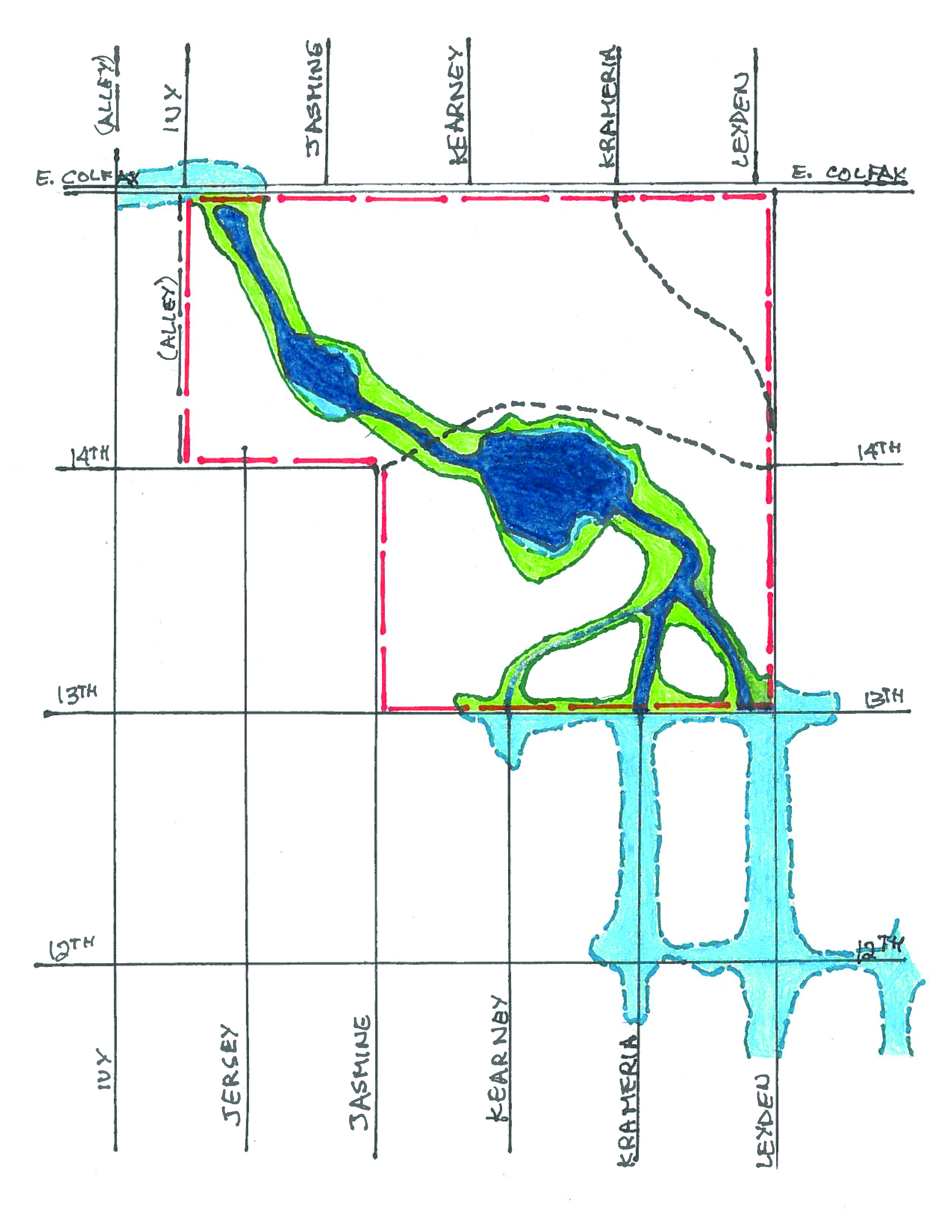
The site is bounded on the north by Colfax Avenue, on the east by Leyden Street, and on the south by 13th Avenue. From 13th Avenue to 14th Avenue, the western boundary is Jasmine Street. At 14th Avenue, the boundary jogs one and a half blocks west from Jasmine to the alley halfway between Jersey and Ivy. It then turns north and extends along that alley from 14th Avenue back to Colfax.
As was the case at Lowry and Stapleton, years ago a creek that flowed through the government facility was relegated to an underground pipe system. Every so often, when it rained hard enough, vehicles would get stranded, buildings would get wet, and any valuables stored in certain basements would be soaked. Some speculate that – like Lowry and Stapleton – this project will also include some creek restoration.
I’m aware that there are pragmatists, realists, deniers, even cynics out there with a doubtful view toward this story. I also know that a lot of people view streams, floodplains, urban redevelopment, open space and parks, fun places for lunch or dinner, walking or biking to shopping or other services without cynicism.
They appreciate some level of unpredictability, grit, and “urban character.”
I present here a very general “bubble” concept plan for the restoration of a creek that really does cross that area of land. During very large rain events, Denver’s Storm Drainage Master Plan, updated in 2010, estimates flows of approximately 800 to 1000 cubic feet per second would enter the “site” along its southern edge (13th Avenue) via Leyden and Krameria Streets.
That Master Plan estimates flows of 1,300 to 1,500 cubic feet per second would exit “the site” at Jersey and Colfax, where the stormwater turns sharply from northbound to westbound for the next several blocks of Colfax.
Imagine further that Krameria and Kearney do not extend from 13th to Colfax. Jasmine and Jersey do not extend from 14th to Colfax. 14th Avenue does not extend from Jasmine to Leyden. So, picture this:
Two branches of the creek enter from the south (along Leyden and along Krameria) and cross 13th Avenue.
Water flows through two open channels that join together approximately halfway from 13th Avenue to “14th Avenue,” along “Krameria Street.”
The branches join and, just west of “Krameria Street,” a single channel enters a pond.
The pond outlets to a west-flowing open channel along “14th Avenue”, which crosses “Kearney Street” and then turns to the northwest as it approaches “Jasmine Street”.
Slightly north of “14th Avenue,” along the west side of “Jasmine Street,” the northwest-flowing channel enters a second, smaller pond.
The outlet channel for the second pond continues north/northwest across “Jersey Street” to an inlet structure that directs the stormwater into the existing pipe flowing west under Colfax.
Next month, you’ll see land use “bubbles” that assume at least as much density as is currently permitted. That density would be rearranged substantially to interface logically with the “creek and pond” bubble and with the site’s perimeter.
Brian Hyde is an expert in floodplain management and stream restoration. He wants your feedback at westerly_connect_brian@comcast.net or 720-939-6039.

