Going Higher
You Can’t Beat A Day Trip To Rocky Mountain National Park, Especially When Denver Temps Climb To Triple Digits
Story and photos by Reid Neureiter
For the GPHN

It is a regular question for Park Hill residents. You have friends coming in from out of state and they want to see the mountains and some wildlife, but they only have a day to explore. What to do?
In this author’s opinion, the most bang for the traveler buck is a day trip spent driving a loop through Rocky Mountain National Park. First, climb the spectacular Old Fall River Road, which terminates above treeline at the Alpine Visitors Center at 11,796 feet elevation. Then return via Trail Ridge Road, across the alpine tundra, to Estes Park. Trail Ridge is the highest continuous paved road in North America—topping out at 12,183 feet elevation.
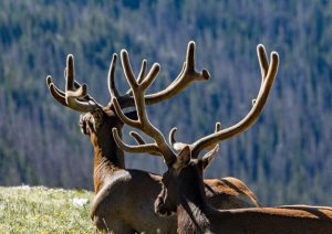
Spectacular mountain views, both of the Never Summer Range west of the Continental Divide, and Longs Peak (at 14,259-feet, the only Fourteener in the Park) are guaranteed. And wildlife sightings are highly probable, including bull elk in full velvet and inquisitive yellow-bellied marmots. There are also plenty of places to park, get out and explore hiking trails that seem to reach to the top of the world.
 The Park now has a timed entry system that requires a reservation permit for entry between 9 a.m. and 3 p.m. (One exception: The hugely popular Bear Lake Road requires reservations between 5 a.m. and 6 p.m.) Reservations can be obtained at the recreation.org website. If you get an early start and arrive at the Park before 9 a.m., no reservation is needed to get to Old Fall River Road. The entry to the Park is $30 per vehicle for a one-day pass, or $35 for a seven-day pass
Going the back way

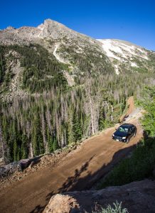
I recommend avoiding the main park entrance at Beaver Meadows and going to the Fall River entrance, just northwest of Estes Park. This “back-way” has less traffic and passes the Sheep Lakes area in Horseshoe Park, where bighorn sheep and moose are sometimes taking an early morning drink. Just past the Sheep Lakes, take a right turn toward the Lawn Lake Trailhead and toward the Endovalley picnic area, for the start of Old Fall River Road. The paved road gets narrower and eventually turns to gravel as it begins its climb through the pine forest and up the mountainside.
Construction of Old Fall River Road, the first transmontane road across the Continental Divide in the park area, began in 1913 to provide a connection between Estes Park and Grand Lake and to serve the increasing numbers of tourists visiting the area. The road was eventually completed in 1920.
 Today, the well-maintained gravel road is fine for passenger cars. The grades can be steep — up to 16 percent in some locations. According to the Park Service, early passenger cars sometimes had to climb the steep grades in reverse because of their weak engines and gravity-fed fuel systems. The narrow road is one-way, with the occasional pull-out for passing or parking to take in the views. There are no guard rails, but a 15-mph speed limit should keep motorists safe. The slow speeds and smooth gravel make this a popular road for cyclists looking for a high altitude workout.
As you wind you way up Old Fall River Road consider stopping for a hike at the Chapin Pass Trail, which travels through pine forest before popping out above treeline and offering fabulous views to the north and east. The truly ambitious can use this path to reach the summits of two Thirteeners in the Mummy Range, 13,075-foot Mount Chiquita and 13,520-foot Ypsilon Mountain.
Birthplace of glaciers

Before reaching the terminus of Old Fall River Road at the Alpine Visitor Center (restrooms and a gift shop), the road climbs next to the alpine Fall River Cirque, an amphitheater-like formation that holds snow into July, and which the Park Service describes as the “birthplace of glaciers that once worked their way up and down the mountain valleys.”
At the Alpine Visitor Center, the visitor motorist should take a left hand turn onto the better known (and much busier) Trail Ridge Road heading east back towards Estes Park. Trail Ridge Road is itself an engineering marvel, with a number of overlooks and parking spots for travelers to enjoy the views or take short hikes.
 Overlooks include the 12,080-foot Lava Cliffs, which are a rare section of volcanic rock in the Park. According to the Park Service, the Cliffs resulted from lava flow around 28 million years ago. Further east, the “Rock Cut” area of Trail Ridge Road provides access to the Tundra Communities Trail, a paved one-mile family-friendly trail with interpretive signs explaining the tundra ecosystem. But the trailhead starts at 12,110 feet in elevation, so even acclimated visitors may find themselves short of breath. Remember to drink lots of water.
Completing the entire loop, up Old Fall River to Trail Ridge Road and back to Estes Park, can be completed in as little as two hours. But with stopping for the views, the wildlife, and even a high alpine hike, visitors can easily spend most of the day exploring the National Park Service’s Rocky Mountain jewel.