Buckley Annex Could Enhance Montclair Creek

The watershed is generally referred to as “the Montclair Basin”, without the word “Creek”. From its source in the higher terrain at Fairmount Cemetery, in the northern part of the George Washington High School site and in Cranmer Park, through the middle of the watershed in and around City Park, to its confluence with South Platte River in Globeville, today’s Montclair Creek is not remotely like other creeks in Denver. 19th century settlers in Greater Park Hill and neighborhoods to the northwest apparently saw little value in Montclair Creek and quickly made it “disappear”. Although the creek has been piped and covered over, any time that it rains hard enough (like July 7, 2011 and July 7, 2012), we are reminded it’s still there; in between those rain events, we, like our predecessors, can act as though the creek doesn’t exist. It has been made into a barely recognizable and essentially invisible part of our city’s storm sewer, street and park infrastructure. It is even an unintended component of Denver’s medical infrastructure, encompassing parts of three hospitals (which it occasionally floods).
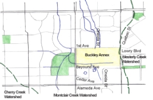 Buckley Annex is east of Crestmoor Park, across Monaco Street Parkway. The site is a rectangle, ½ mile (E-W) by ¼ mile (N – S). Monaco and Quebec are, respectively, the western and eastern boundaries. 1st Avenue and Bayaud Avenue (or its extension) are, respectively, its northern and southern boundaries.
The northern and eastern parts of Buckley Annex drain north to the Park Hill Branch of Montclair Creek. Stormwater from Fairmount Cemetery and nearby higher ground passes through Buckley Annex, trying to find the historic channel of the Park Hill Branch. It flows north across 1st Avenue, generally toward the intersections of Magnolia and Niagara with 6th Avenue Parkway. From those intersections, stormwater then flows north and northwest through East Montclair, and on to City Park.
From the southern and western portions of Buckley Annex, stormwater coming from as far away as George Washington High and Cranmer Park flows toward the Hale Parkway Branch of the creek. It flows west and northwest through Buckley Annex, crosses Monaco and enters Crestmoor Park. Besides that stormwater flow from Buckley Annex, tributary drainages convey stormater into Crestmoor Park’s bowl-shaped depression from the southwest, the west, and the northwest. The park was deliberately modified to enhance the natural bowl shape and allow filling of it by stormwater, with the outlet being located at the northeastern corner. Once the bowl is full, excess water will flow north to the intersection of Locust Street and 1st Avenue on its way to Hale Parkway and City Park. The detention of stormwater in Crestmoor Park lessens stormwater flows to the north and west on the Hale Parkway Branch, reducing flooding of streets, houses and hospitals downstream.
Stream restoration projects could be implemented along the drainages in Buckley Annex, with streamside trails integrated into the riparian corridors. Constructing those projects and extending the restoration efforts to the existing drainages in Lowry and East Montclair to the north and in Crestmoor Park to the west could create strong greenway linkages. The potential is there to initiate the revitalization of both branches of Montclair Creek and to create an east-west link tying those two branches to each other. In addition, there is an opportunity to link with Westerly Creek, the next watershed to the east.
Brian Hyde wants your feedback at westerly_connect_brian@comcast.net or 720-939-6039.