Bringing Urban Watershed Planning To Park Hill
Harvard Gulch Similarities Abound
The Denver Urban Waterways Restoration Study is a relatively new project in our city. The stated purpose of the project is, “to identify restorative improvements to three major urban waterways (Harvard Gulch, Weir Gulch, and the South Platte River from 6th to 58th Avenues) in the City and County of Denver.” Project sponsors are:
• The United States Army Corps of Engineers
• Colorado Water Conservation Board (the State of Colorado’s floodplain management agency)
• Urban Drainage and Flood Control District (our regional floodplain management agency in the Denver metro area)
• Transportation and Wastewater Divisions of the Denver Department of Public Works
• Denver Parks
Studies and planning efforts are already underway for these three urban waterways in Denver. How about such an effort for the Montclair Creek watershed? Note that Denver’s 2014 Storm Drainage Master Plan described the Montclair Creek watershed as “the largest storm drainage basin in Denver which does not have a surface drainageway.”
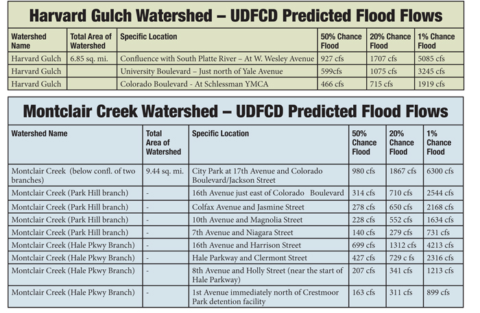
Of the three watersheds currently under study, the Harvard Gulch watershed in southeast Denver strikes me as the most similar to the Montclair Creek watershed. Landmarks in the Harvard Gulch watershed include Porter Hospital, Denver University, and the Schlessman YMCA. The stream generally flows from east to west parallel to and near Yale Avenue. It originates near Monaco Street and Yale, crosses under Colorado Boulevard at the Schlessman Y and continues “behind” Denver University at University Boulevard, passes near Porter Hospital, and then joins the South Platte.
The accompanying table presents a few quick statistics about Harvard Gulch; statistics for Montclair Creek are shown in the second table.
The tables show specific locations along the stream where predicted flood flows for various probabilities (% chance) were calculated. The calculations for those flood flow predictions followed the methodology specifically required for flood hydrology studies within the Denver metro area’s Urban Drainage & Flood Control District (UDFCD).
The Urban Drainage & Flood Control District was created by the Colorado legislature shortly after the devastating 1965 flood on the South Platte River. As soon as the district hired staff, they developed, tested, implemented, and have continually adjusted a technical hydrology methodology based on our unique meteorological conditions in the Denver area. They have instrumented many watersheds to measure, in real time, rainfall and stream flows and then used the data to, if necessary, revise and update their methodology.
Three locations along Harvard Gulch to characterize the watershed; nine locations were chosen for Montclair Creek. The flows are shown as “X% flood,” as opposed to “Y-year flood,” to emphasize that floods are statistical events, not part of a repetitive cycle where they wait until it’s their year to happen.
So why pursue an Urban Watershed Restoration Study?
Last month I said my goals are to simultaneously address:
• Flood risk
• Bike/ped transportation, connectivity of parks and open space, enhancement of the health and aesthetics of the community
• Wildlife habitat as well as recreation and health opportunities
• Water quality and reduced channel erosion
The project goals stated in the Harvard Gulch study are:
• Reduce the flood hazard area
• Develop a sustainable corridor
• Denver Parks is actively seeking to expand their land
• Improve natural areas in riparian zones with “wild spaces” between programmed activity centers
• Help the stream develop a channel that is stable to reduce sedimentation
Those two lists of goals look like a good match to me.
As always, my overarching objective is to enable the connection of people and their communities with their watersheds. In May, I discussed the wonderful work being done by Environmental Design students from CU for the Park Hill watershed. The work of those students in Boulder provides a strong start toward an Urban Watershed Restoration Study.
Completing two such watershed studies, covering the two watersheds that include virtually all the territory in our neighborhood, would provide invaluable guidance for many future decisions regarding a great variety of issues in Greater Park Hill.
Brian Hyde is an expert in floodplain management and stream restoration. He wants your feedback at westerly_connect_brian@comcast.net or 720-939-6039.