Floodplains Are for Floods

It was the summer of 1991. The state agency where I worked had just hosted the Association of State Floodplain Managers (ASFPM) national conference.
In my Park Hill yard, one of the attendees, Alan Wald with the State of Washington Department of Ecology, was describing to me an education and awareness program they had put together about flood risk and wise floodplain management. Then he stated their simple, but profound, slogan, “Floodplains Are for Floods.”
He did not say, “Floodplains are for:
• Houses and apartment buildings
• Grocery stores, restaurants, gas stations and auto repair facilities
• Hospitals and churches;
• Extremely busy streets and highway intersections, stretches of historic U.S. highways, or city zoos;
As a footnote or an afterthought, for floods, if there’s any space left.“
I’ve never forgotten that moment. In part because yes, one of each of the above land uses exist in the floodplain of Montclair Creek — including the Denver Zoo.
Denver’s recent Storm Drainage Master Plan says, regarding facilities that existed at the time of the plan’s adoption, that the amount of floodwater set by the city’s current drainage criteria, the “initial storm (2-year recurrence for residential areas and 5-year recurrence for commercial/industrial areas), cannot be fully conveyed within pipes or dedicated drainage channels.”
The master plan goes on to say that the “current system is generally undersized except for major drainage ways (e.g. South Platte River, … Harvard Gulch)…”
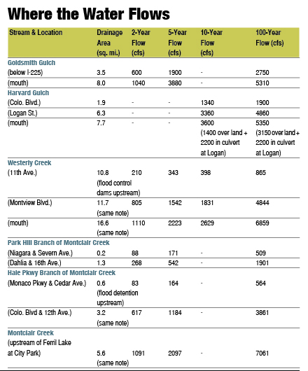
Let’s examine the case for treating Montclair Creek as a “major drainage way” instead of as a system of pipes and some “local ponding areas.” Below are important statistics about three streams in Denver whose floodplains were first mapped about 35 years ago, and all of which have subsequently been regulated and managed as major drainage ways. The same information is included for Montclair Creek, as well.
All three other streams are the subjects of ongoing stream restoration efforts.
Last month I asked how implementing Major John Wesley Powell’s proposal about watersheds and drainage divides might look.
I submit that it would look much like the open space networks at Stapleton and Lowry (Westerly Creek), which are soon going to be even better, and like the best portions of the open space networks on Goldsmith Gulch and Harvard Gulch. I also submit that Montclair Creek is worthy of at least a little bit of the same Watershed Love.
Next month – What might that Watershed Love look like?
Brian Hyde is an expert in floodplain management and stream restoration. He wants your feedback at westerly_connect_brian@comcast.net or 720-939-6039.
Where the Water Flows